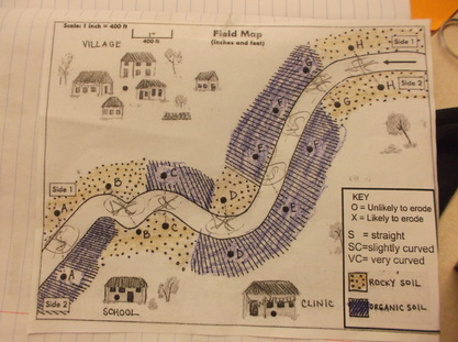
With Suman's Field Map in hand, second graders spent time "dissecting" the map so that they can better understand where the TarPul could be built. We used the key to help us evaluate every possible site, focusing on these three questions:
1. What type of soil does the site have on each side of the river?
2. How does the shape of the river at each site affect the soil's ability to erode?
3. How far is the site from the village to the school and clinic?
We'll be focusing on these questions as we test each possible location and ultimately make a recommendation as to where we should build the TarPul. Go geotechnical engineers!